Location: South Duck Hunting Stand
Managed by: Glacial Ridge National Wildlife Refuge
Management Address
17788 349th St. SE (Polk County 210)
Erskine MN 56535
Glacial Ridge is located in the Mississippi Headwaters/Northern Tallgrass Prairie ecosystem. It is a key component of the prairie pothole mix of small wetlands surrounded by upland prairies and woodland savannas. This mix of small wetlands and uplands are crucial as breeding habitat for an array of migratory birds, including waterfowl, songbirds, shorebirds, and others. http://www.fws.gov/refuge/Glacial_Ridge/about.html The refuge is open for public use via foot traffic only with the exception of using driving routes that lead to the accessible hunting stands for people with disabilities and people accompanying them. To qualify as a person with a disability in order to drive to and use the stands the person must be determined eligible for benefits for one of three Social Security Disability benefit programs, possess a State issued permanent Accessible Parking Permit, and/or have a 50% or greater impairment rating by the Veterans Administration. This stand is placed over a wetland area that supports brooding and migrating puddle ducks. It is accessed by a ramp that extends from the car trail to the stand floor.
Description
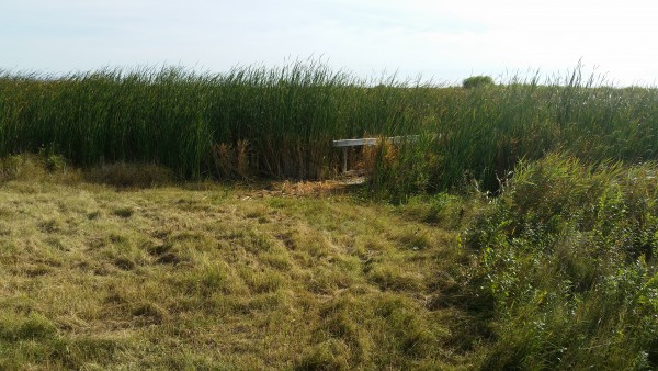
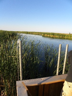
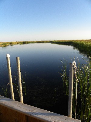
The southern stand located within the depths of Glacial Ridge National Wildlife Refuge jets out over a finger of water that collects before a spillway that keeps water even on drier years. This area is the culmination of various drainage systems that release water slowly into a large impoundment located further downstream. This stand on normal wet cycle years should be located in an area that sees waterfowl moving between these systems especially puddle ducks but also during the great migration other waterfowl seeking the larger bodies of water this area has to offer.
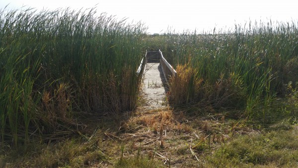
The stand itself sits on south side of a point of land that offers it a great deal of camouflage from ducks flying in from the north. It is also very grown over now with vegetation so that the ramp and railings are covered by willows, cattails and bulrushes. Hunters can travel directly next to the ramp to transfer atop it so that they can use it to access the stand deck. The deck is built on a steel frame that can be adjusted in order for it to remain level. The deck and side panels are made of wood, either planking or plywood dependent on the piece. The bank gradually meets the water so that you do not have to worry about large changes in elevation from bank to water in this area. At the spillway, at least 100 yrds south, there is a significant drop in elevation from the slew surface to the drainage system. From what has been experienced the slew bottom seems to be hard gravel and does not seem to pose a problem for hunters setting decoys or picking up fallen game. For persons with slight ambulatory disabilities if you can navigate the high willows that surround the blind the slew bottom should not pose a significant barrier, though we do not know if there is any drop offs in the slew, rocks placed in other locations, or if the bottom should turn soft so that it is a sinking danger.
This is very remote it is very important you inform someone you trust when you are leaving and when you are coming back and where this stand is located. Very few people know of this stand so it is unlikely that you or a friend could even call emergency personnel and they would know where you would be calling from. With the GPS located on a cell phone it will look like you are in the middle of a couple of sections of land. So please be proactive and set up a safety net for yourself. There is no Refuge Staff on duty weekends and on weekdays the one or two staff could be miles away working. The calendar is developed to insure hunters don’t travel great distances to find the stand is being used, it is NOT for your safety. I do not know how to stress this enough, if you are hurt it may be weeks before your body would be found.
The ramp approach is level with the ground by digging it into the ground but users are cautioned that if any heavy rains have taken place there may be erosion making the transition greater than ½ inch.
Location Info » For directions, click the marker in the map. »
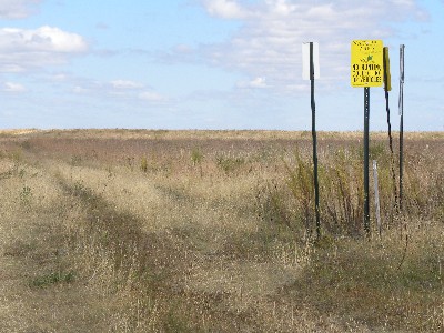
This stand is located approximately 12 miles from Fertile, MN. Travel 7.5 miles north from Fertile and turn left (west) on 360th St SW travel 2.8 miles to 135th Ave SW. At 135th Ave SW turn right (north) and travel on road until it turns into a trail where you will follow the trail past a drainage ditch/culvert to a group of signs on the right. Immediately past the group of signs you will see a set of wheel tracks heading to a ridge. When you get to the ridge top travel parallel to the slew to the north following the set of wheel tracks/mowed trail until you reach the stand, the stand is set into a mixture of cattails and willows.
Amenities
The closest town is Fertile which has food, gas, and a grocer (south seven miles on Hwy 32). The refuge has accessible porta-potties available during warmer weather please visit the USFWS web-site link for location.
Lodging
The closest sleeping accommodations are located on Maple Lake (Inn at Maple Crossing) south of Mentor as well as the cities of Fertile, Red Lake Falls, Crookston and Fosston. Camping is allowed within many of the smaller towns located along Hwy 2 such as Erskine and McIntosh.
Reserve this Element
You must be logged in to reserve elements.
You can login or register here.
